Showing posts with label Montana. Show all posts

Thursday, October 17, 2013

Fresh tracks!

-->
The Northern Bridgers with a fresh coat of September snow

September provided the mountains around Bozeman with their first seductive layer of white since last season. Few ranges look as comely as the Spanish Peaks’ northern flanks in the sultry colored half-light of the morning. I looked on wistfully each day on the bike ride to work, weighing the merits of long approach for fresh turns against the core shots that would inevitably result from the thin early season snowpack.
Patience was rewarded the following week, when a snowstorm dumped upwards of a foot in the high mountains around town. The northern Bridgers were socked in and I was able to finagle my way out of work Friday — under the pretense that the adventure get written up for the Chronicle’s Outdoors section — and hit the mountains with my friend Tyler.
Ready to rock
Trust in the two SNOTEL sites in the Bridgers led us first to Ross Peak, where an alleged seven inches waited. By the time we reached the trailhead, however, it was clear that the meadows we originally planned to ski didn’t have enough coverage to make us forget about the rocks underneath.
           
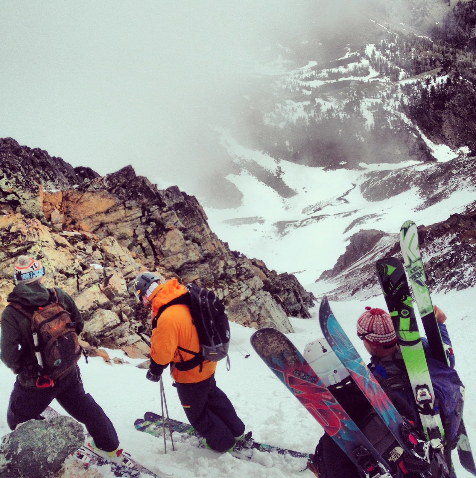
We careened back down the access road and headed to Sacajawea to ski a couloir that Tyler knew about. It had a pretty quick approach and dropped into Frazier Basin. Not only that, but in the small pullout area there was a Subaru containing the wild-eyed teleskier I met skiing Sacajawea in June and while skiing the Blaze in July. Since we were planning to ski the same area, the two of us and the teleskier — his name is also Jason — and his dog, Pepper, trekked up together.
Jason and Pepper assessing the conditions
            
We made it to the top of a distant knob in good time. Snow conditions were excellent there, with thigh-deep light, soft snow. The deep areas were created by wind, which had apparently blown most of the snow out of a chute Jason knew about and had hoped to ski. Instead, Tyler led us over to a neighboring chute farther west that turned out to have the best coverage of what we could see.
           
The first dozen turns were incredible. A brief straight-line to pick up speed. Quick turn to test out the snow. Then a few turns in the drifted gully created by the steepening slope. The 10 inches of cold smoke kicked up around our shins and aroused thoughts of true winter.
A fine start to the run
           
Those thoughts were quickly bedded back down, however. The light snow only concealed the rocks with its beauty rather than offer a loving, supportive barrier to shield P-Tex from jagged stone. As soon as we reached the heart of the slope, it was obvious the coverage was no longer enough to barrel downhill. But we agreed to billy goat our way to the bottom in the interest of traversing the bowl and scoping out other lines before skinning back to the knob.
           
Talk turned a bit to how the early season snowfall could affect the winter’s snowpack, but all apprehension was outweighed by the fun of those turns at the top. There’s little you can do about the weather but enjoy it when it comes. I suppose we could cross our fingers and hope the storms come with some regularity, which they have so far this fall. But if the last several years have shown anything, it’s that storms are going to arrive when they will and it likely won’t be with any dependable consistency.
           
“The storms are acting what I call ‘more bipolar,’ too,” Doug Chabot, director of the Gallatin National Forest Avalanche Center, said in Porter Fox’s new book, DEEP: The Story of Skiing and the Future of Snow. “We get these crazy swings. We might get a big snowstorm that feels like winter, followed by unseasonable warm, sometimes record-breaking temperatures. They have this manic feeling to them. We can’t just settle into winter anymore.”
           
Fox was kind enough to provide an advance copy of his book and will join the Seneca podcast this week, discussing both the book and some of his experiences around southwest Montana and Jackson, Wyo. He’s familiar with the area, even writing about skiing out the south end of Bridger Bowl for Powder in March.
           
Several lines stood out while we trekked parallel to the southern edge of Frazier Basin. A mental checklist was made for later this season when a big dump — hopefully! — will fill in and prevent skiers from hitting the bottom or any weak layers nefariously left over from these early season storms.

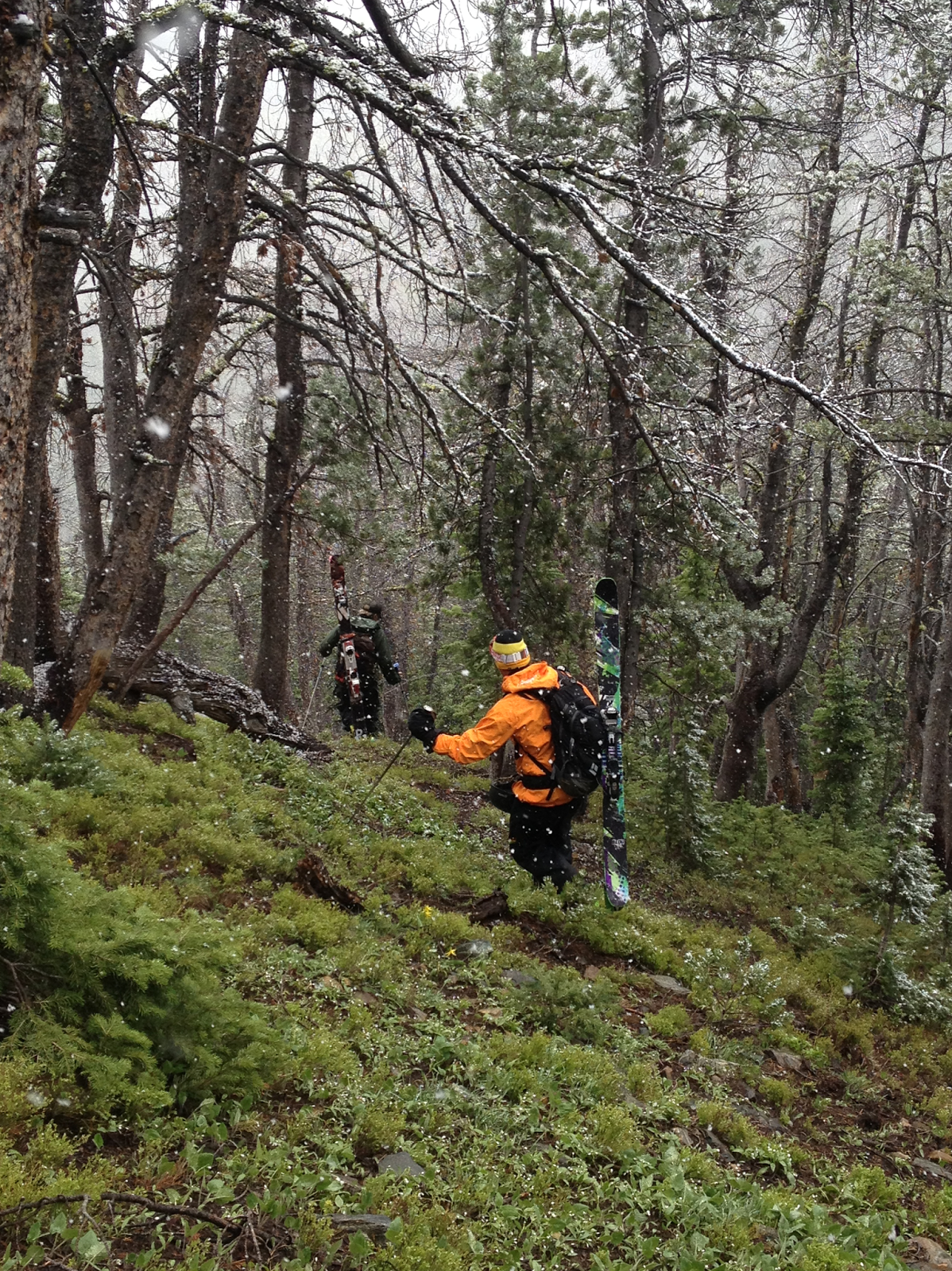
Finally back atop the knob, Tele Jason sent it down the low-angle drainage back to the car first. It was a smooth return with only a couple telltale dinks here and there from rocks while crossing the meadows. The dinks ended up turning my skis into one of the most mangled pair of boards a ski tech at the Round House had ever seen. It was hard to worry too much about that with a beer in hand and a snow covered mountain range in the background, and one more month until hitting 12 consecutive months of skiing.
Skiing back to the car is vastly underrated
-- Jason Bacaj

Wednesday, September 18, 2013

Mt. Blaze, redux


Sunrise in the Spanish Peaks
 
Any grand adventure is bound to go wrong at some point along the way. The adventure doesn’t really start until then. Mountain trips are particularly finicky in this way, dependent on weather and snow conditions and the temperament of the mountain itself — sometimes it’s determined not to let you on. August’s ski trip was one akin to that.

I went to bed the night of Aug. 19 happy about the elevated platform I'd built to house my ski gear and stoked about a trip planned for the upcoming weekend to ski the Whitetail Couloir. Then I had something of a prophetic dream... I found myself at a bar in western Pennsylvania not unlike one I visited once in high school after skiing Seven Springs Resort, my home mountain then.

Outside there were two lifts servicing a poor excuse for a mountain. But it had a decent enough angle to get turns in and the snow looked deep, despite it obviously being mid-summer. I was on the lift looking down at my skis when all the sudden I came tumbling down many feet into the snow below. The fall left me unhurt but I was stuck in the deep pow with my skis on unable to truly maneuver. My mind went blank as I unclipped and worked my way until the skis were on my pack and I was ready to trek uphill and earn my summer turns.

When I looked at the path ahead, though, the snow had melted. A rocky, depressing incline rose before me after all that falling terror and work to get myself unstuck and ready to rock.

The next morning I called the good people at Sylvan Mountain Sports in Red Lodge to see if anyone knew of the snow conditions on Whitetail. No one really knew, but I was given camping tips and felt solid about the recon. That dream kept nagging me in the back of my mind, so I posted on the shop’s Facebook wall to see if anyone frequenting the page had recently made the trip.

It was passed along that a climber up there had seen 'very grim' snow conditions -- a narrow strip of ice at the top and an icy gravelly mix stretching halfway down the scenic couloir.
You say "grim," I say east coast conditions. Although it isn't the Whitetail Couloir

Things started falling apart from there. Skiing buddies were blowing out their knees, moving to new houses around town, leaving for weddings. Meanwhile, wildfires started popping up around the area and temperatures were consistently hitting the 90s. The Whitetail Couloir trip was scrapped and it certainly looked like the world was conspiring against anyone skiing in Montana in August.

I hit up my buddy who made the drive from Phillipsburg to Bozeman the prior weekend to see if there was snow on the Blaze, just trying to scrounge a backup plan for August. He didn't really look and couldn't say. Another buddy who trekked up to Butte that day didn't make it back until dark and couldn't say either.

I made up my mind to make a lightning-quick solo mission up the Blaze to claim whatever turns were to be had, if any. It was disappointing that the Whitetail trip fell apart because, in addition to being an aesthetic line, it would’ve required a little bit of mountaineering along the way.
Sometimes you take weird pictures when you wake up three hours after heavy drinking to hike 14 miles.

So in the spirit of using the summer to practice techniques to be used during winter, I went out and partied downtown until the bars closed as a little warm up for the classic endurance challenge of “last call, first chair.”

Waking up at 5 a.m. after a night that started off with pint of Jack & Coke was a little rough, but I got on the Spanish Creek trailhead in an hour and a half and was feeling pretty good, if not a little cold, tromping around in Chacos. The first hour or so of the hike flew by, probably because I wasn’t fully awake or sober at that point. Then I climbed the first couple switchbacks wrapping around the Blaze and looked back across the drainage at a black bear apparently munching some berries not 30 yards off the creek I had just crossed.
Summer backcountry skiing holds somewhat different dangers

Much more concerning was that there wasn’t any visible snow at that point. I was starting to get more than a little concerned that this was just a speed hike, until I got off trail and started bushwhacking toward the peak. The view from the scrub pine revealed a short, thin strip of snow — what turned out to be 250 vertical feet.

A group of three mountain goats showed me a path up the rocky slope. The Chacos didn’t afford much protection from falling rocks and protruding ledges, but my bruised feet carried me to the top of the snowline by 10:30 a.m. or so. The sun had just peeked over the top of the mountain and hadn’t softened up the wavy, icy snow.

Ready to get weird atop some classic east coast packed powder

The strip of snow was wide and long enough to slide around and string together around 15 turns or so. I thought about heading back up for another quick run after reaching the bottom. I’ve adopted the Montanan habit of packing everything humanly possible to do in one day into each summer weekend, however, and had to run back into town for a friend’s afternoon party.

I headed out hopeful for September’s adventure and pretty stoked that the August gamble paid off.

Here's hoping we get some new snow in September

Thursday, August 8, 2013

Gettin' Blazed


Amanda, Jen, Tyler, Brett and dogs Marley and Tero ready to get rad after hiking about 13 miles in two days with loaded packs. They're definitely not thinking about the seven more required to get out.

Bridger Bowl’s opening day is close enough to put a little twinge of excitement in the bowels of any degenerate skier. But right now we’re in the thick of the summer, and a getting turns in requires enough determination to hoof through a 20-mile round trip into the mountains.

Which is what we did in July, hiking out to ski the 10,400-foot Mt. Blaze. It’s the fifth highest mountain in the Spanish Peaks, a small range within the Madison Range just about 40 minutes or so out of Bozeman depending on how comfortable you are bombing down the well-maintained dirt road that traverses one of Ted Turner’s vast properties.

The Blaze is a popular backcountry spot, and one that was suggested by John Graves — a hardcore skier I ran into on Sacajawea in June who had a 5-year stretch where he skied every month of the year. The only questions were just how much snow was back there and how the hell to actually get there. It seems like a large portion of Bozeman’s backcountry aficionados have skied it, but none could provide any more detailed directions than, “hike about four miles, take a right across a creek, take a left across the same creek a while later and then you should see it,” which is roughly how John described the trek. In his defense, the directions were tossed out while he was gearing up for some conference or another in Puerto Rico.

The first question was answered while driving back from the Missoula Marathon on July 14 on I-90. A long tongue of snow ran slightly left of the peak almost to the tree line.

I figured that we’d play the second one by ear after getting a group of four others — Amanda, Brett, Jen and Tyler (and two dogs, of course) — together. We set out at the crack of 10 a.m. or so and reached the Spanish Creek trailhead an hour later.

If you squint just right, you can see the silhouette of Marley (a black lab) on top of the packs
 
Four-and-a-half pretty flat miles later we found ourselves where the trail diverged. We chose to head up to Mirror Lake, half because we weren’t really sure where to go and also it just seemed like a good place to figure out what to do. The last couple miles up to the lake were switchbacked and steep and took their toll on the group. When we got up there and realized how tough it’d be to scale the Blaze from the backside, the decision was made to set up camp and think it over.

They did not taste like boots
Amanda and I hiked up a rise on the way up to Summit Lake and scouted out two potential routes for a backside approach. One was up a scree field capped with a small snowfield and then along a ridge to the top. The other followed an avalanche path up to a northern ridge, which looked like the most do-able from our vantage point -- except for one section that looked awful cliffy for our climbing gear-less party. On the positive side, we found some morels hiking back to camp, thanks to my expert analytical yell of, “Hey, aren’t these sorrels or something?"


After some discussion, we decided to wake up at dawn and hike down, around and up the mountain for our turns.

A fine campin' spot

It was a chilly morning, but we were quickly warmed by the hike back to where the trail split. We ditched gear to lighten the now excessively heavy packs and headed toward the Spanish Lakes, after a brief panic when Tyler’s dog, Marley, disappeared. He popped up on the trail maybe a quarter mile and several minutes of quiet freaking out later.

Miles into the trail we ran into a wild-eyed teleskier I met coming down Sacajawea (popular spot!) who gave us somewhat more specific directions on where to start bushwhacking. Basically, it was dead ahead and marked by a cairn. Of course.

Just over the next rise!
We bushwhacked our way slowly uphill because the miles were starting to add up on everyone’s legs, except for the dogs and Brett. When we were most of the way up a skier and snowboarder made their way down the surprisingly wide and long track. The snow looked like prime spring corn, even if they didn’t return our radness yell. He had a GoPro on, so he was probably concentrating really hard on not screwing up on camera.

But we finally reached the peak around 2 p.m. and geared up for the descent. The snow was a little slushy on top, streaked with dirt and pocked infrequently with the tips of rocks. After all the requisite pictures were taken, we pointed out skis and went for it. I noodled down last and the odd pain that had developed in the side of my left knee disappeared with a few wide, easy turns done in an attempt to savor each slide as much as could be done.

It was tempting to just rip down, but knowing we had at least a seven mile hike out helped keep the inner hardcore ski bro safely hidden away deep inside.


Not so bad for July!


The hike out was a pleasant suffer-fest as the knee pain returned and migrated into the hip. Even the dogs were worn out by the time we reached the car. It took Marley a minute of coaxing to jump into the truck bed for the ride home.

But hey, it was turns in July. Can’t wait to make some more in August down in the Beartooths. We’re planning on hitting up the Whitetail Couloir.

-- Jason Bacaj

Tuesday, July 30, 2013

Peak baggin' in the Tobacco Roots

Atop Mt Jackson, the sixth highest peak in the Tobacco Roots, during a brief break in the clouds

June brought us into the heart of the summer with the passing of the solstice, the longest day of the year. One primed for hedonism and vague pagan rituals.

And, surprisingly enough, great skiing.

I was lucky enough to get invited up to a friend’s cabin about 11 miles back in the Tobacco Root Mountains, just about an hour or so west of Bozeman for a party celebrating all of those things. Well, all right. There weren’t any pagan rituals or anything. But we climbed a mountain and skied down it and tried to drink a keg of microbrew — certainly enough to cause anyone to dance around a fire and make wookie noises.

I drove to the cabin relatively late Friday night not entirely sure where I was going. My friend Tyler gave directions the night before after we were both a few beers deep: take the Cardwell exit off I-90, a right onto a Forest Service dirt road that you follow about 10 miles until you pass the mine tailings, then it’s a left and you’ll drive over a chain and past a ‘keep out’ sign. Just follow the road until you reach the cabin. Of course.

Sunrise from the cabin door
Directions that seem strange at first always make sense once you get out in the country, however, and I reached the cabin as the sun was setting. Tyler, Michelle and Phil were all drinking around the stove with a pair of dogs mulling around underfoot. We all sat and drank and talked and waited around to see if Little Phil would show up. More beers were had while everyone watched rain begin to fall. Little Phil arrived and talk turned to how great it’d be if snow was falling at higher elevations before turning in for the night.

The day began around 5 a.m. Saturday with Phil whipping up a manly breakfast of eggs and potatoes. The four of us set off into the morning chill astride a four-wheeler dirt buggy contraption shortly after breakfast. It took about 30 minutes to make it from the cabin to the end of a trail not far from Sailor Lake at the base of Mount Jackson. It took about 20 minutes of bushwhack straight uphill, roughly paralleling a stream, before we reached the snowline.
Montana cat skiing!

As luck would have it, a few centimeters had fallen overnight. We took this and the wide bowl at the base of Mt. Jackson in, eyeing up lines and listening to Phil talk about the good stuff that lies even beyond the surrounding ridgeline.

Then we gathered ourselves, talked it out and decided to bootpack up the main north-facing chute coming off the peak, to summit and possibly ski down, depending on the conditions, before hoofing it along the northeastern side of the mountain. Scrambling up a scree field just below the chute made things interesting, and apparently tore a buckle off one of my boots. They were crappy old Scarpas that I bought for about $20 at the ski swap last year, so I wasn’t all too broken up about it, but I was a little worried about how the break would affect the whole skiing aspect.

One happy effect of the boot breakage was that it was a little easier to hike up the chute, even as the slope angle, wind and snow started to kick up a bit.

The low-vis boot pack up
We peaked out after a decent hike and took the requisite summit photo. It was cold, cloudy and snowy while we munched on pepper slices and cheese. But then the sun broke out for about five minutes to give us a partial view of what the Tobacco Roots looked like from 10,400 feet. Brother, it was a nice way to see the first weekend of summer.

We decided to ski down the chute we climbed — shit, it was a possible first descent, why pass that up? Little Phil claimed firsties and we all took our turn before scrambling across the scree field again to reach the ridgeline and find some more fine lines down the bowl. By the time we reached the bottom, it was pounding snow in near whiteout conditions.
Fresh snow on the first weekend of summer? Sure, why not.

We down climbed back to the buggy and headed to the cabin again to set up for the solstice party, rather than take more laps.
Tyler and Little Phil (orange jacket) lead the hike back down
GPS route from top to bottom

Tuesday, July 23, 2013

On getting quantifiably rad


If you're getting rad but no one sees you, are you really getting rad?
Apologies for the time lag between postings. Since there are only about three months of summer in Montana, you have to cram everything into a tiny amount of time. If you try to do everything you want, it isn’t long until you have a month’s worth of beard growth, several pieces of broken furniture braced with wood cut from pallets, approximately 7,000 pictures and a backlog of writing to do.

But enough diddling around. This blog is primarily about skiing once every month of the year, but when the spirit takes me, it’ll address some key aspects of skiing. This one tackles the age-old question of determining just how rad one gets on the mountain.


Ski long enough — hell, even hang out long enough in a bar near the ski hill — you’ll hear some conversation like this: “Then I hit this like 40 foot cliff with a pretty gnarly run out” or “nah man, we skied that peak outside the boundary, there were cracks shooting out from our skis on the way down, pretty wild!”  It’s a little part of the culture of one-upmanship that can spread throughout a ski town. At Seneca we think it’s pretty funny, though it’s also fringed with a bit of sadness because it can lead people into bad spots they might not be able to get out of.


 After making an Ego Claim (+500 GNAR points) the "best
skier on the mountain" makes his way off toward an Extreme
Brag (+1,000 GNAR points)
All that aside, figuring out how rad you got is a practical necessity in any ski area. Seneca’s founder, former ski racer and Freeskiing World Tour competitor Eric Newman (can’t talk about radness and not mention credentials!), and some buddies came up with one way to get around it: when talking about cliffs, just say if it was small, medium or large. It’s subjective, but it works. Others, like the legend Shane McConkey have taken on this formidable task, most notably Shane McConkey when he developed the game of G.N.A.R.

For the uninitiated, it stands for Gaffney’s Numerical Assessment of Radness. The system offers points for skiing tough lines and doing assorted rad things while skiing them. Points are accumulated over an entire season. An end of season tally determines who won the game of G.N.A.R. for that ski season. The game is an easy-to-follow way to resolve issues of radness over the course of a given season. 

We decided the question needed addressing once more, given all this crazy technology that’s come out since McConkey, the God Among Skiers, created his game. And because it’s always a good time to poke fun at that hardcore culture. Let’s get down to brass tacks.

G.N.A.R. is mostly for those who want to “just have fun” and “end the day satisfied with skiing no matter the conditions” and stuff like that. Save those platitudes for Sunday, bro. That kind of thing isn’t going to fly in a truly hardcore ski town. This entirely serious debate can only properly be solved by science, which boils down to hard numbers. Preferably ones that are already added up for you, thanks to technology.

My high school skiing friends and I did a little investigating into this during our annual ski trip this past March. We were, appropriately, in Squaw Valley and had recently come across a fine smartphone app called Ski Tracks that tallies up speed, total vertical, steepest slope angle and the number of runs completed in a given day, among other things.

It was incredibly important to get as rad as we possibly could on the first day, so we went out there and did work despite fairly terrible spring snow conditions. Our max speed was 61.8 mph; we covered nearly 18,000 vertical feet and more than 16 miles on 11 runs, the steepest of which was 42 degrees, despite the non-rad task of getting passes and such limiting us to a paltry five hours of skiing. Radness quantified!

Of course it was just a scientific one-day test run. None of this actually solved anything. Maybe next year’s ski trip will involve some sort of quantifiable radness competition, complete with a championship belt.

Quantifiable radness!


Monday, June 17, 2013

Into the summer doldrums


Actually this picture was taken during the winter after Andrew
 had to work during an epic storm cycle, but you get the point.
In 2004 I wrote a letter to Alaskan Ski Guide Dean Cummings asking for advice on how to pass the ski-less days of the summer. While I hoped he might have a secret recipe, or just put me at ease knowing Im not the only one suffering, he told me to fish. Ive tried fishing, but while I love the sport Im not much of a fisherman. So then I bought a trials bike and headed to the dirt jumps...and broke 3 ribs. I tried mountain biking and someone stole my bike. I like waterskiing and wake-surfing, but there arent any lakes around Bozeman, so I got into rock climbing, but last summer fell 50ft, broke my ankle and scared the last shred of summertime hope out of myself.
After realizing I was no good at most of the summer pass-times, or what I might be any good at significantly lowered my life expectancy, I started looking for more skiing. I've been backcountry skiing for almost 10 years and strung a few seasons together where Ive skied every month of the year. This year I met Jason Bacaj at one of the Seneca Parties at our new shop. He's a writer for the Bozeman Daily Chronicle and avid skier, and we decided to work together on documenting the summer doldrums of a skier and the quest to get turns every month of the year. His quest starts like most, on the roadside chutes of the Beartooth Highway. Jason will be checking in every month with updates on his adventures so be sure to check our website or subscribe to the blog or our facebook page for his regular updates!
         -- Eric Newman

 Indoctrination of a ski bum

         It hardly snowed my first winter as a season pass holder at Bridger Bowl. You could only ride the quad to the midpoint until January. And no matter how many times my friends told me, hearing that the lift used to close because there was too much snow didn’t make it any better. Still, the handful of powder days to be had changed the way I viewed skiing. Hiking to steep terrain, skiing thigh-deep powder and having to study lines on the lift ride to make sure you don’t cliff out — it was a far cry from the high-speed ice carving and tree skiing I grew up on in West Virginia.
The Beartooth Pass is even more gorgeous than you think
            The snow remaining on the mountains around Bozeman nearly all summer called to me between ski seasons. By the time my second winter rolled around I made up my mind to ski at least once each month of the year and somehow tricked Eric Newman, owner of Seneca Boards, into letting me write about it for his site.
            The first seven months were easy. Skin up to Bridger before the season starts then ride through the end of the year in April. There’s still snow at Bridger and in the other ranges that ring Bozeman but the way to start the hard leg of this journey isn’t with a swift jaunt 16 miles north of town.
            It just so happened that the Beartooth Pass was scheduled to open up Memorial Day weekend, which also happens to be my birthday weekend. Obviously, it was a sign from God that the Beartooth Pass is where this adventure needed to start. And after watching about a month of snow plowing videos I was pretty stoked to get down there, even though my small crew bailed to float the Smith River.
            The solo drive was a little rough after taking a few days to celebrate the fact that I survived a quarter-century of life. But I made it to Red Lodge and found Red Lodge Ales Brewing Company’s taproom in due time. A friendly chef told me about some free campgrounds just outside the pass. After a couple beers I headed out to check out the pass.
The pass switchbacks from an elevation of about 5,500 feet at nearby Red Lodge to almost 11,000 feet on its way to Yellowstone National Park and is as dramatic as it sounds. I went up to check out the Gardner Headwall, just past the Wyoming line, in the couple hours of sunlight that were left. The snow was soft and I got in a couple runs on low-angle stuff before the light waned and I had to try and find the campgrounds.
Tempting steeps, dangerous conditions
Sleep was hard to come by in the backseat of the Volkswagen Jetta, loaded as it was with ski gear. I packed up and headed back up the pass a little after 6 a.m. It was frozen corn but the headwall skied all right. The steeper chutes were mighty tempting but a wet slide at the bottleneck of an hourglass chute kept me on the low-angle slopes again.
I admired a distant snowstorm at the bottom of the run before starting the hike back up. Maybe 10 minutes later as I scrambled up some rocks on the way to the top, the distant storm was on top of me pounding snow and high winds. Thunder and lightning were crashing around by the time I reached the top. It was whiteout conditions when I reached my car and headed back down the pass.

 The heavy low hanging clouds and rain on Highway 212 gave the world a sharper color and introspective aura. It was a good start to the adventure. The next one won’t include any car camping.